The need for a Resilient Housing Plan is dramatically revealed each hurricane season. Unfortunately, for communities that find themselves dealing with the aftermath of a destructive storm, making a plan can't wait for the next disaster. The motivation to help cities, counties and parishes produce a Resilient Housing Plan is apparent in the too often repeated situation of a municipality being unprepared for a disaster and thousands of people being left without the leadership, assurance and financial assistance that they need in the challenging work to repair and rebuild lost and damaged housing.
After securing a grant from Smart Home America funded by US EPA, Planning & Zoning has contracted the Louisiana-based consulting firm Desire Line, LLC to develop a Community Resilience Housing Plan. The goal of the Resilient Housing Plan can be simply explained in three statements: reduce damage and loss of current housing; effectively apply for, receive and use funding after a storm; and, improve planning and building standards for new and renovated housing to reduce damage and loss in future storms.
Utilizing a Conservation and Restoration Partnership Award from the Louisiana Coastal Protection and Restoration Authority, St. John the Baptist Parish will plan, design, and restore Sunset Park to include rip rap for the first layer of shoreline protection, backfill bank stabilization, and the planting of native marshland plants to further stabilize the northern portion of the park.
The objectives of the restoration include:
- Restore 1.5 acres on the western side of Pass Manchac to include 650 linear feet of shoreline protection measures.
- Plant native tree, grass, and flowering species.
- Conduct public outreach with stakeholders, residents, local fishermen, and businesses.
A Multi-Scale Green Infrastructure Strategy for St. John Parish – Pilot Project
Addressing flooding and managing stormwater through nature-based solutions.
Our Approach
In October 2023, St. John the Baptist Parish was selected as a winner of the Greater New Orleans Foundation’s (GNOF) Next 100 Years Challenge. The grant is intended to strengthen the infrastructure and hazard mitigation solutions to help build a safer, more equitable Southeast Louisiana for the next 100 years.
St. John the Baptist Parish’s GNOF Next 100 Years project intends to advance the use of green infrastructure and integrate nature-based solutions into planning for stormwater management and nuisance flooding. The drainage system has physical limitations on the amount of water that it can handle during a given rain event. To help complement the drainage system, green infrastructure can help store rainwater where it falls and filter it into the ground.
Source: New Orleans Redevelopment Authority
This project will help to develop a multi-scale green infrastructure strategy that:
- Identifies incentives for landowners to implement green infrastructure for lot-level stormwater retention
- Increases street retention and conveyance
- Improves stormwater retention at the base of the West Shore Lake Pontchartrain Levee
Working with community partners that have experience in green infrastructure and environmental resilience, St. John will pilot a green infrastructure project in the Parish during the first phase of project implementation. The second phase is to secure additional funding for a larger Green Infrastructure Strategy for St. John’s East Bank.
Phase I: Pilot Project
- Identify a project for implementation
- Plan and design the project
- Monitor the benefits of the project
Phase II: Green Infrastructure Strategy
The Problem
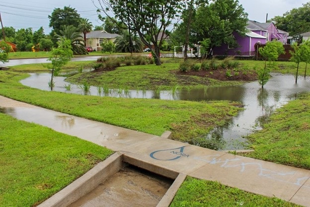
The East Bank of St. John Parish relies on a series of gravity driven drainage canals to move stormwater from populated areas towards Lakes Pontchartrain and Maurepas. Nuisance flooding, or low levels of temporary flood inundation, can occur when rain falls more quickly than the drainage system can move it off of the streets. Nuisance flooding is a disruption for residents’ day-to-day lives that can inundate both roadways and yards. The West Shore Lake Pontchartrain Levee Project will provide monumental flood protection for St. John residents during extreme weather events like hurricanes. However, even with the installation of the levee, there is still a need to consider nuisance flooding. For example, on St. John’s East Bank, stormwater is often slowed in the drainage system when it needs to cross certain barriers like railroad tracks or roadways as it makes its way toward the swamps. Even in leveed communities like the City of New Orleans with large pump systems, there are still areas that experience nuisance flooding during heavy rain events.
What is Green Infrastructure?
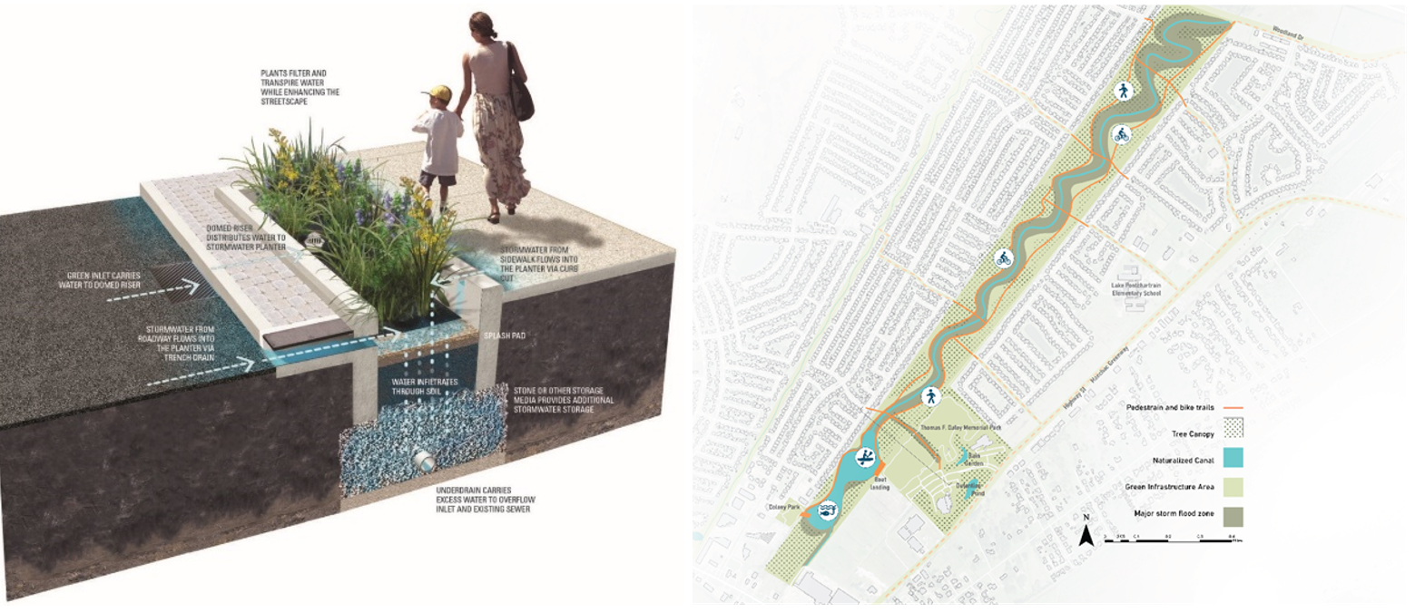
Green infrastructure is a broad term that generally describes the use of nature and man-made interventions to capture, filter, and absorb rainwater where it falls. Examples of green infrastructure include rain gardens, bioswales, permeable pavement, and rainwater harvesting. In comparison, grey stormwater infrastructure describes conventional drainage systems using culverts, pipes, and drainage ditches.
Source: Urban Conservancy Source: North Carolina State Cooperative Extension
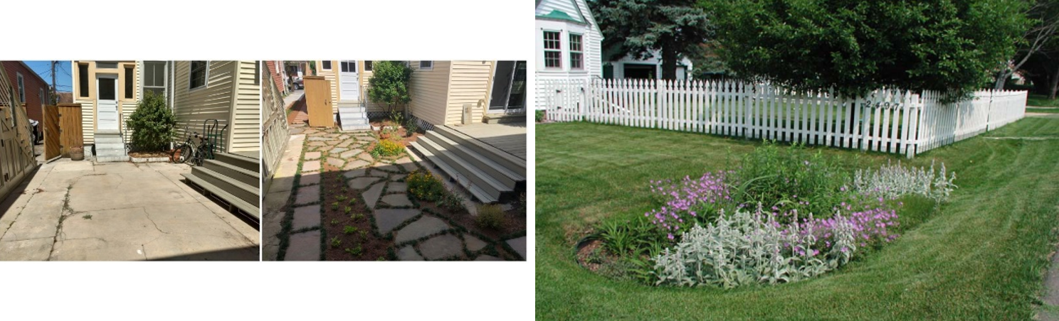
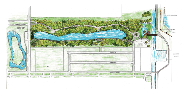
Green infrastructure solutions can be implemented on different scales. On a property level, a homeowner can plant a rain garden or replace a driveway with permeable pavers. On a street or neighborhood level, local governments can design bioswales that run along roadways or redesign a park to hold stormwater when it rains. On a larger system scale, protecting wetlands and preserving open natural spaces helps serve as green infrastructure for a much bigger area.
Have you noticed the ongoing roadway updates on Airline Highway and Main Street? Many elements of this project include green infrastructure improvements like a stormwater park and permeable pavement. You can learn more about green infrastructure and different green infrastructure solutions here.
Source: Philadelphia Water Department Source: LSU Coastal Ecosystem Design Studio
Source: St. Bernard Parish
About our Partners

The LSU Coastal Ecosystem Design Studio (CEDS) is an interdisciplinary research center that brings together natural and social scientists, engineers, designers, and planners to work collaboratively on complex issues related to living with water. These interdisciplinary teams take a systems approach to research and problem-solving, focusing primarily on human settlement in deltas and coastal areas, flood protection, socio-economic sustainability, ecosystem design and restoration, and community resilience. CEDS works at a range of scales—from small city blocks facing urban stormwater management issues to multistate watersheds—studying the dynamic nature of water; its actual and projected impacts; and how people might safely live with it, in addition to engineering it's hydrology.
New Wine Development Corporation operates to improve the lives of children and families by providing innovative programs, specifically Kids on the Move STEM Summer Camp, Kids on the Move STEM Before and After Care, Emergency and Transitional Housing, a Food Pantry, as well as Long-Term Disaster Response Relief and Recovery (LTRG). Our goal is to ensure that families within St. John the Baptist Parish not only thrive, but importantly, positively affect the economic viability of the community at large. Contributions to St. John the Baptist Parish Community:
- KOTM STEM Summer Camp serves nearly 400 campers annually
- KOTM STEM Before & Aftercare serves nearly 100 scholars throughout the school year
- NWDC’s Emergency and Transitional Housing provides emergency and transitional housing to those most in need in St. John Parish
- NWDC’s Food Pantry provides meals for more than 300 families per week
- Most recently, NWDC’s LTRG received a total of 961 homeowner assistance requests through the Volunteer Reception Center post Hurricane Ida. We have successfully completed 957 requests. In the past year, we have assisted approximately 431 homeowners with building materials and repairs. In addition, we have housed over 502 volunteers who have come from many states to assist St. John residents with the rebuilding of their homes.
The Water Collaborative (TWC) is the regional leader in urban water management and climate adaptation strategies. We create unique and necessary methods to our world's most pressing issue, water, through our collaborative working groups, interdisciplinary approach, and multi-objective problem-solving. Our mission is to build a diverse network for all who are impacted by flood risk by focusing on equitable practices to help communities sustainably live and thrive with water. We believe everyone has a role to play regarding stormwater management, flood prevention, climate change adaptation, and mitigation. By bringing design professionals, urban planners, non-profits, social enterprises, neighborhood associations, elected officials, and concerned citizens together, we create smarter and unique opportunities for collective thinking for innovative and practical models of water resilience.
Since 2001, the Urban Conservancy (UC) has collaborated on and led initiatives to strengthen the urban environment and local economy through equitable practices, policies, and programs. We promote sustainable solutions to Southeast Louisiana’s' distinct land use needs through K-12 and neighborhood-level engagement. Since 2015, our Front Yard Initiative has provided technical and financial assistance to 163 property owners to remove over 93,000 square feet of paving and improve drainage to reduce flood risk and manage 3.5 million gallons of rainwater annually.
About the Greater New Orleans Foundation:
With roots extending over 100 years, the Greater New Orleans Foundation connects generous people to the causes that spark their passion. As one of the most trusted philanthropic organizations in the region, we work every day to drive positive impact by championing charitable giving, strengthening nonprofits, and leading civic initiatives in our thirteen-parish region. In addition to grantmaking, we convene people, resources, and ideas to create intelligent strategies and solutions to meet our region’s greatest challenges. We are proud to serve as a vocal civic leader with our partners to ensure an economically and culturally vibrant, sustainable, and just region for all. Learn more at www.gnof.org.
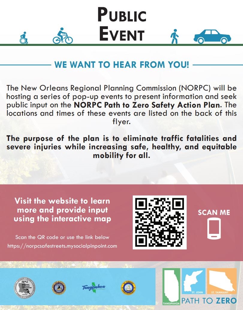
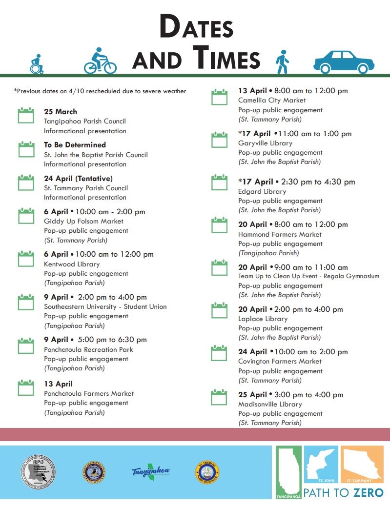
New Orleans Regional Planning Commission (NORPC) Preparing Path to Zero Safety Action Plan for Tangipahoa, St. John the Baptist, and St. Tammany Parishes
The New Orleans Regional Planning Commission (NORPC) is proud to announce the development of a Path to Zero Safety Action Plan. This transformative initiative aims to revolutionize transportation safety in Tangipahoa, St. John the Baptist, and St. Tammany Parishes.
Purpose and Vision: The Path to Zero Safety Action Plan is a collaborative effort driven by NORPC, Parish Administration, and community stakeholders. Its primary goal is bold and ambitious: to eliminate all traffic fatalities and serious injuries on our roadways. By implementing specific, data-informed, and proven transportation safety countermeasures and strategies, we envision a future where every journey is safe, secure, and free from preventable harm.
Funding and Support: This visionary plan is made possible through a Safe Streets and Roads for All (SS4A) discretionary grant program established by the Bipartisan Infrastructure Law (BIL). The SS4A program supports the U.S. Department of Transportation’s National Roadway Safety Strategy and its goals of zero roadway deaths using a Safe System Approach.
Public Engagement: We invite all residents, businesses, and organizations in Tangipahoa, St. John the Baptist, and St. Tammany Parishes to actively participate in shaping this transformative plan.
Learn more at: https://norpcsafestreets.mysocialpinpoint.com/
Here’s how you can get involved:
- Interactive Map: Visit our website and explore the interactive map. Share your ideas by marking up the map with safety suggestions and improvements.
- Survey Participation: Take our survey to provide valuable insights. Your feedback will directly guide the development of plan goals, priorities, infrastructure projects, and recommended strategies.
- Team members will be visiting area libraries, grocery stores, festivals, and farmers markets to tell community members about the Path to Zero Safety Action Plan and gather their input. Event locations will be posted on the website.
Plan Components: The Path to Zero Safety Action Plan will encompass the following elements required by the SS4A grant program:
- Data-Driven Approach: Our strategies are informed by comprehensive data analysis to identify high-risk areas.
- Safe Infrastructure: Upgrading roadways, intersections, and pedestrian crossings to meet the highest safety standards.
- Education and Outreach: Launching targeted campaigns to educate people who drive, walk, or bike about safe practices.
- Community Engagement: Engaging residents, schools, businesses, and advocacy groups to foster a culture of safety.
We encourage everyone to join us in this critical endeavor and contribute their insights.
Next Steps: The planning team, comprised of Volkert, Inc, ATG|DCCM, Urban Systems, Inc., Grey Engineering, Svaapta Group, and the UNO Transportation Institute will use input from the public and their technical analyses to prepare the Path to Zero Safety Action Plan. A draft report is anticipated in Fall 2024.
To learn more about the project, please visit: https://norpcsafestreets.mysocialpinpoint.com/
Or contact us at: NORPCSafeStreets@gmail.com