Floodplain Regulations & Plans
Understanding Base Flood Elevations & Flood Maps
Flood Insurance Resources
Hurricane, Flood, and Natural Hazard Resources
West Shore Lake Pontchartrain Levee
FEMA publishes maps showing flood hazard areas and the degree of risk in those areas. These maps are on file at your local library, the Parish Administrative Offices (1811 W. Airline Highway in LaPlace), and online. Check with the Parish Planning & Zoning Department by calling (985) 651-5565 or emailing StJohnFloodplain@stjohn-la.gov, to see if your property is in a special flood hazard zone.
Did you know that your property may be located in a flood prone area? You're not alone. Over 87% of St. John the Baptist Parish has been designated by the Federal Emergency Management Agency (FEMA) as a Special Flood Hazard Area. Special Flood Hazard Areas in St. John are designated as Zones AE and VE. Property owners in Flood Zones AE and VE are required to carry flood insurance if they have a federally backed mortgage.
Zone AE is referred to as the "100-year floodplain," meaning that this is an area that will flood an average of once every 100 years, with a 1% chance of being flooded in any given year. Put another way, there is a 30% chance of your property being flooded over the life of a 30-year mortgage. Flood zone VE is an area where wave action is likely to occur over and above the flooding. The areas along the shore of Lakes Maurepas, Pontchartrain, and Lac Des Allemands are designated as VE Zones.
Localized flooding can occur anywhere in the Parish, even outside of the Special Flood Hazard Area when isolated rainstorms drop large amounts of rain in relatively short periods of time. Areas outside the Special Flood Hazard Area are still part of the “500-year floodplain” and will have a 0.2% chance of flooding in any given year.
To learn more about the flood hazard of your property, you may request a flood zone determination from your Floodplain Manager
Contact: St. John Planning & Zoning Department (985-651-5565)
You can also view your property’s flood hazard information at stjohnla.withforerunner.com/properties
Most standard homeowner's insurance policies do not cover losses from flooding. You are eligible for flood insurance because St. John the Baptist Parish participates in the National Flood Insurance Program (NFIP), administered by FEMA. If your property is in the Special Flood Hazard Area (which includes all AE and VE Flood Zones in St. John Parish), you are required to purchase flood insurance to secure a federally backed mortgage.
Your insurance agent can help you decide how much coverage you need. Need help finding an insurance agent for flood insurance? Visit floodsmart.gov, email FloodSmart@fema.dhs.gov , or call 1-877-336-2627.
Keep flood insurance records safe. Once you have purchased flood insurance, keep your policy and an itemized list of your furnishings, clothing, and valuables in a safe place. Remember, or carry in your wallet, the name and address of the agent or broker who wrote your policy. Call your agent or broker immediately if you suffer flood damage.
Do not wait. There is a 30-day waiting period before an NFIP-backed policy becomes effective. Floods can happen anytime. Additionally, you must have an active flood insurance policy to be eligible for FEMA mitigation grant programs.
Risk Rating 2.0. On April 21, 2022, the NFIP implemented a new rating methodology for flood insurance premiums called Risk Rating 2.0. Learn more about Risk Rating 2.0 here: https://www.fema.gov/flood-insurance/risk-rating. St. John the Baptist Parish is actively monitoring these changes and participates in the Coalition for Sustainable Flood Insurance (CSFI). Learn more about CSFI here: www.csfi.info.
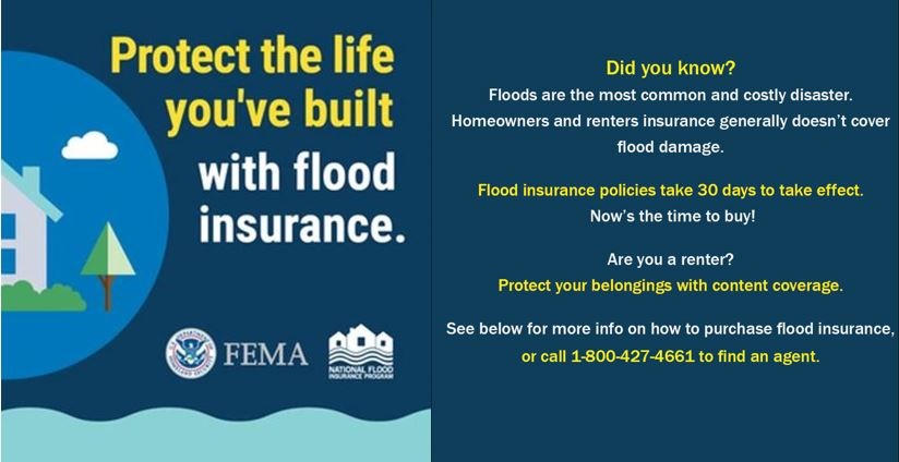
Renters and business owners can also purchase policies to protect their personal contents. As a renter, even if your landlord has flood insurance on the building, it will not cover your personal belongings. o protect your personal property it is important to purchase contents-only flood insurance, sometimes called renters flood insurance. Standard renters insurance policies typically do not cover flood damage. Without renters flood insurance you would have to replace flood-damaged property such as clothes, electronics, and furniture out of pocket. Learn more information on flood insurance for renters here.For homeowners and business owners, building coverage and contents coverage are purchased separately from one another. Flood insurance can be purchased up to the maximum amount of insurance available for the following property types (including both building and contents coverage):
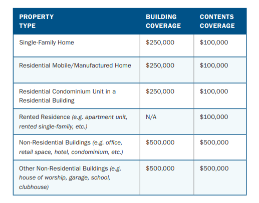
Learn more information about commercial flood insurance here.
Learn more information about why you need flood insurance here.
Safety is St. John the Baptist Parish’s priority during actual or potential flood hazards. Stay prepared:
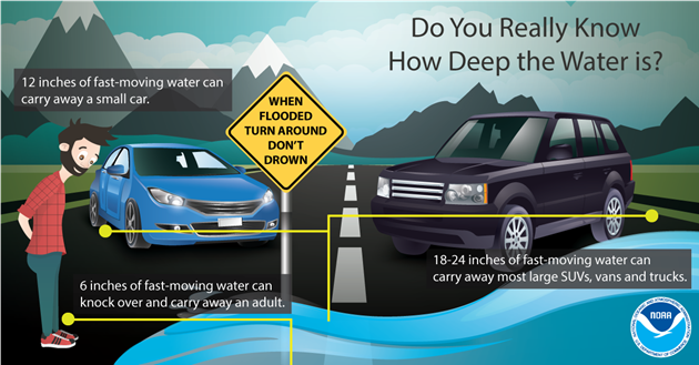
If you see flood water on roads, walkways, bridges, or on the ground, do not attempt to cross. The depth of the water is not always obvious, and water can hide damage or dangerous debris on the road. Be aware of areas where flood waters have receded and watch out for debris.
If you are caught in a building during a flood, move to a higher floor or the roof. Take a tool in case you need to break through the roof. Take drinking water, a flashlight, and a portable radio. Wait for help.
In St. John the Baptist Parish, flooding can occur during any season of the year. Your property may be in a Special Flood Hazard Area as determined by the Federal Emergency Management Agency (FEMA). The principal sources of flooding in St. John the Baptist Parish are rain and coastal inundation from Lakes Pontchartrain, Maurepas, and Des Allemands.
Flood water collects in low areas and land that is prone to subsidence or sinking. Gravity drainage can only move so much water in a severe weather event given our low, flat topography. When the ground is saturated, and heavy rain falls quickly, the drainage system can be overwhelmed, and flooding can occur. There are many things you can do to an existing building to minimize or eliminate the potential for flood damage.
Temporary measures to minimize flood damage:
- Sandbags (remember to avoid stacking sandbags directly against outer walls of a building since wet bags may cause damage to your foundation)
- Plywood
- Plastic sheeting
- Water-inflated barriers
- Battery powered sump pump
Permanent measures to minimize flood damage:
- Elevate building/contents
- Build floodwalls or closures
- Elevate mechanical equipment such as water heaters, air conditioners, and washers and dryers on platforms
- Install a sewer backflow valve
- Grade soil and redirect gutters away from buildings
You can get information on retrofitting from the main parish public library in LaPlace. In addition to retrofitting booklets, the main library has publications on flood insurance, flood protection, and floodplain management. Another resource for flood protection information can be found at the LSU AgCenter’s LaHouse: https://www.lsuagcenter.com/topics/family_home/home/lahouse.
Did you know that you can request a site visit or phone call to discuss local flood problems and get advice on floodproofing techniques for your property?
Contact your Floodplain Manager in St. John’s Planning & Zoning Department by calling (985)-651-5565
or e-mailing StJohnFloodplain@stjohn-la.gov to learn more.
Ask before you build. Before proceeding with any construction, development, or flood retrofitting measures check with the Parish Planning and Zoning Department at (985) 651-5565 for applicable building codes, permit requirements, and zoning restrictions. Always use a licensed contractor.
Developments in the Special Flood Hazard Area have specific elevation requirements to protect structures from flooding and maintain compliance with the National Flood Insurance Program. You can build beyond the minimum requirements. Contact the Floodplain Manager in Planning and Zoning to discuss construction techniques that will minimize flood damage and may help reduce flood insurance premiums.
If you observe any illegal development in the floodplain, please report it immediately to the Code Enforcement Division at (985) 359-1185.
Did you know that you can apply for a permit online?
Visit: sjbparish.gov/Departments/Planning-and-Zoning/Building-Permits
Additions, reconstruction or rehabilitation of your property is subject to National Flood Insurance Policy (NFIP) requirements. Check with the Planning and Zoning Department before proceeding.
The NFIP requires that when the cost of reconstruction, rehabilitation, addition or other improvements to a building equals or exceeds 50% of the fair market value, then the building must meet the same construction requirements as a new building. Substantially damaged buildings must also be brought up to the same standards. A residence or building damaged so that the cost of repair equals or exceeds 50% of the structure's fair market value must also be elevated to the Design Flood Elevation (DFE) in the Special Flood Hazard Area (Flood Zones AE and VE). Questions about these requirements may be directed to the Planning & Zoning Dept. at (985) 651-5565.
Floodplains are lowland areas adjacent to lakes, wetlands and rivers that are covered by water during a flood. Floodplains carry and store flood water, serving as a natural reservoir that reduces the extent and frequency of flooding.
Undeveloped floodplain also provides numerous natural and economic resource benefits. They have high biological diversity and productivity. Floodplain vegetation and soils serve as water filters, intercepting surface water runoff before it reaches nearby lakes. This process aids in the removal of excess nutrients, pollutants and sediments from the water.
You can help minimize flooding and pollution by keeping catch basins in front of your property clear. Every resident of St. John can help enhance the environment we rely on for drainage and recreation.
St. John the Baptist Parish Planning & Zoning Department helps protect the natural floodplain functions through regulations like our stormwater management ordinance and Environmental Conservation Zoning District. Planning & Zoning also manages resilience and restoration projects to help preserve our floodplains.
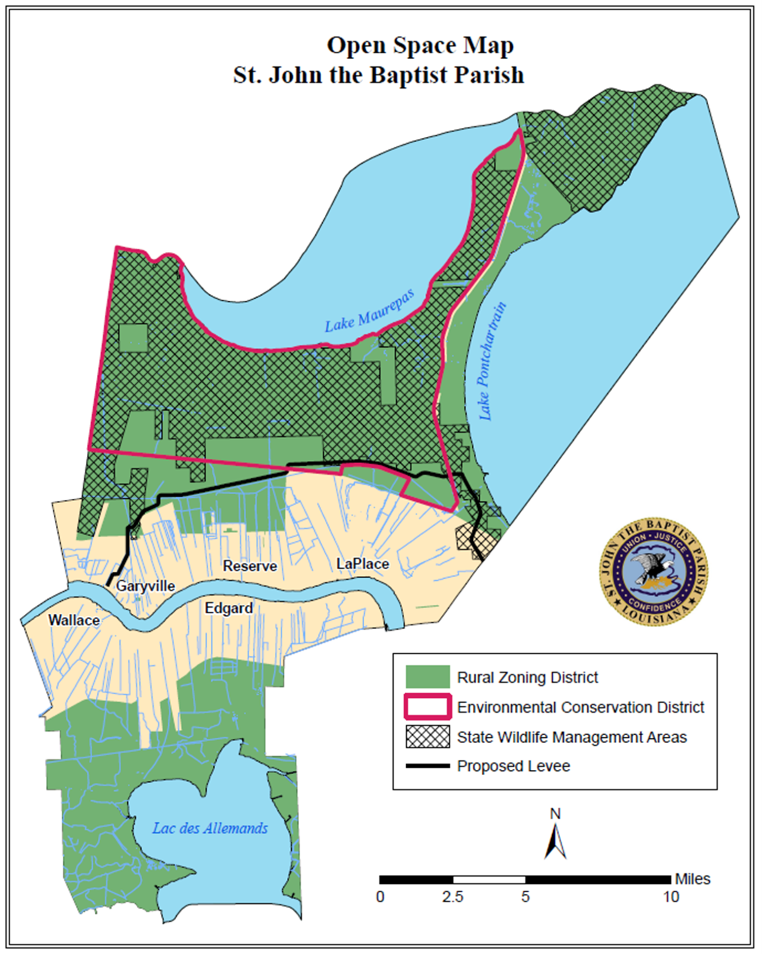
In Louisiana, six specific types of flooding are of main concern: riverine, flash, ponding, backwater, urban, and coastal. In St. John the Baptist Parish, all six types of flooding have been observed. The Parish’s low, flat ground makes gravity drainage a challenge.
Riverine flooding occurs along a river or smaller stream. It is the result of runoff from heavy rainfall or intensive snow or ice melt. The speed with which riverine flood levels rise and fall depends not only on the amount of rainfall, but also the capacity of the river itself, as well as the shape and land cover of its drainage basin. The smaller the river, the faster that water levels rise and fall. Thus, the Mississippi River levels rise and fall slowly due to its large capacity. Generally, elongated and intensely developed drainage basins will reach faster peak discharges and faster falls than circular-shaped and forested basins of the same area.
Flash flooding occurs when locally intense precipitation inundates an area in a short amount of time, resulting in local stream flow and drainage capacity being overwhelmed.
Ponding occurs when concave areas (e.g., parking lots, roads, and clay-lined natural low areas) collect water and are unable to drain.
Backwater flooding occurs when water slowly rises from a normally unexpected direction where protection has not been provided. A model example is the flooding that occurred in LaPlace during Hurricane Isaac in 2012. Although the town was protected by a levee on the side facing the Mississippi River, floodwaters from Lake Maurepas and Lake Pontchartrain crept into the community on the side of town opposite the Mississippi River.
Urban flooding is like flash flooding but is specific to urbanized areas. It takes place when storm water drainage systems cannot keep pace with heavy precipitation, and water accumulates on the surface. Most urban flooding is caused by slow-moving thunderstorms or torrential rainfall. Urban flooding problems are exacerbated by impervious surfaces such as concrete and asphalt.
Coastal flooding occurs when normally dry coastal land is flooded by seawater but may be caused by direct inundation (when the sea level exceeds the elevation of the land), overtopping of a natural or artificial barrier, or the breaching of a natural or artificial barrier (i.e., when the barrier is broken down by the sea water). Coastal flooding is typically caused by storm surge, tsunamis, or gradual sea level rise.
Before the Storm
Prepare a personal evacuation plan. Visit getagameplan.org.
- Identify ahead of time where you could go if you are told to evacuate.
- Keep handy the telephone numbers of these places as well as a road map of your locality.
- You may need to take alternative or unfamiliar routes if major roads are closed.
- Listen to Parish officials for evacuation instructions. Make sure everyone in your household knows and understands your hurricane evacuation plan.
St. John Parish Assisted Evacuation Plan - Mandatory Evacuation Only
- St. John Parish will transport residents via school bus to public shelters in North Louisiana. Residents will be registered, and each person will be allowed one suitcase.
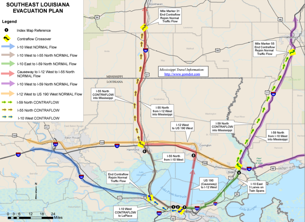
Southeast Louisiana Contraflow
- Contraflow will be a last resort. If used, traffic will flow east on Interstate 10 to the Slidell area, where Interstate 12, Interstate 59, and Interstate 10 meet. From there, people can decide which way they want to go.

Stay prepared and aware.
Recent storms like Hurricane Ida have gained strength and intensity very quickly, making it difficult to determine if there is sufficient time to order a mandatory evacuation. The decision to leave ahead of a storm may be an individual one for you and your family. Monitor storm strength and track at the National Hurricane Center’s Website: nhc.noaa.gov.
St. John the Baptist Parish is home to numerous plant and animal species that all rely on water to survive and thrive. Our vast areas of wetlands and swamps also offer recreational and economic opportunities for our community. Improving water quality is important for plants, animals, and residents! Actions you take on your property impact the Parish’s drainage canals and St. John’s wetlands.
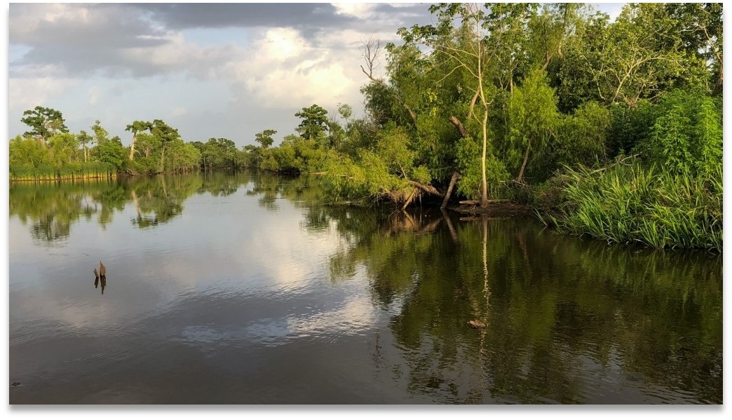
St. John the Baptist Parish Planning & Zoning Department is overseeing several projects aimed at improving water quality and reducing flooding through green infrastructure. Planning & Zoning also partners with local, regional, and state-wide entities like the Louisiana Watershed Initiative and Barataria-Terrebonne National Estuary Program.
To learn more about water quality, St. John’s watersheds, and the species that inhabit St. John:

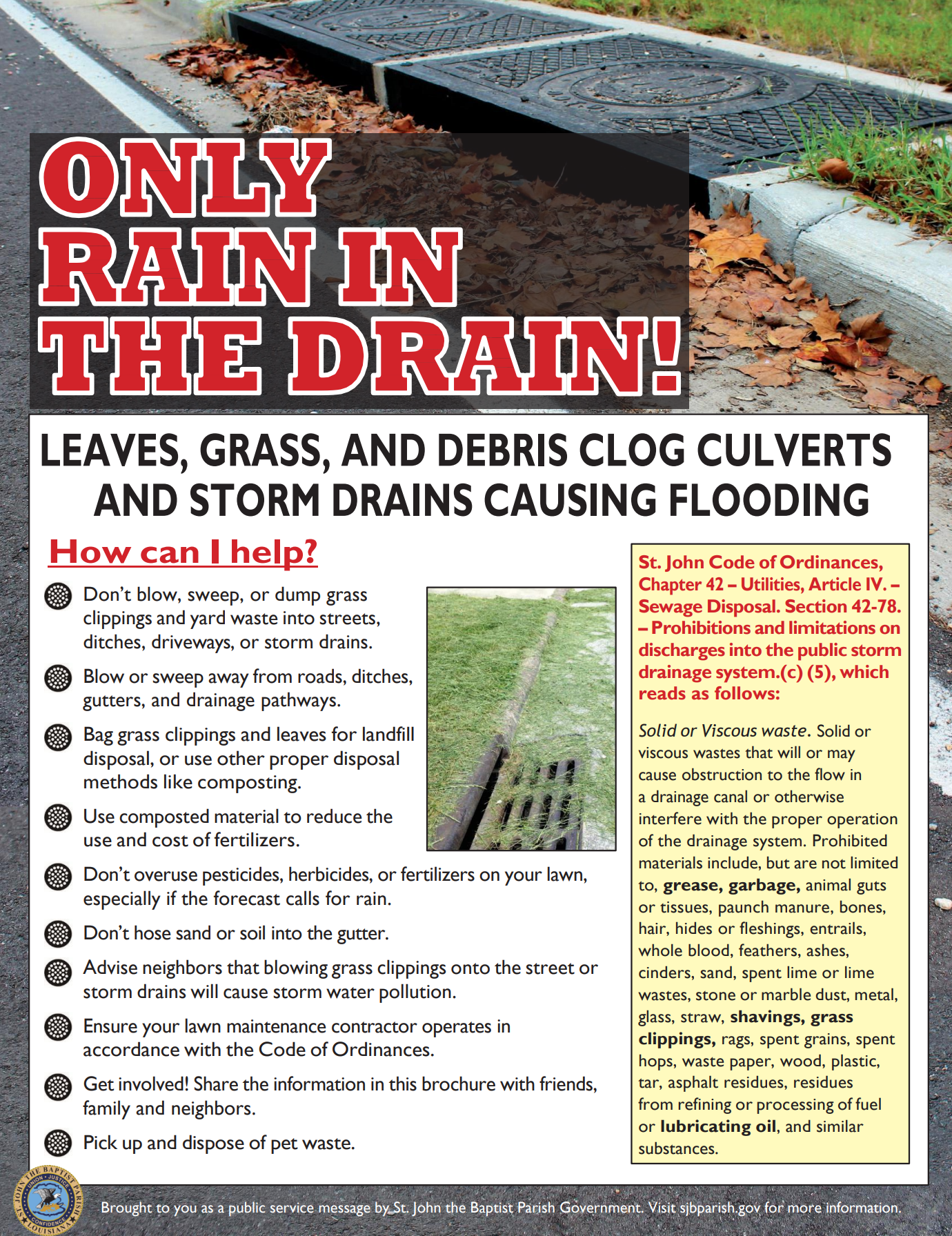
To be habitable, our parish needs to have a drainage system. The Public Works Department has a regular program of drainage system maintenance. You can help by clearing the catch basins in front of your property. Per section 26:150 of the St. John Parish ordinance, dumping debris in catch basins or in drainage ditches and canals is prohibited and is punishable by a fine. Contact the Public Works Department at (985) 652-4815 if you have questions about the parish's drainage system.
St. John the Baptist Parish has a robust communication system to keep residents informed during emergencies and inclement weather.
Local and Regional Gauge Resources.
The National Weather Service, an agency of the National Oceanic and Atmospheric Administration (NOAA), offers an Advanced Hydrologic Prediction Service local map showing 297 gauges across southeast Louisiana, southern Mississippi, and western Alabama that report water levels in real time. In addition to river observation, the webpage also offers information on river forecasts, long-range flood risk for the next 3 months, precipitation amounts, and downloadable observations and forecast data. There are four gages on the map located in St. John the Baptist Parish: two in Pass Manchac, one in the Maurepas Swamp, and a Mississippi River gauge near Reserve. View the Advanced Hydrologic Prediction Service map viewer here.
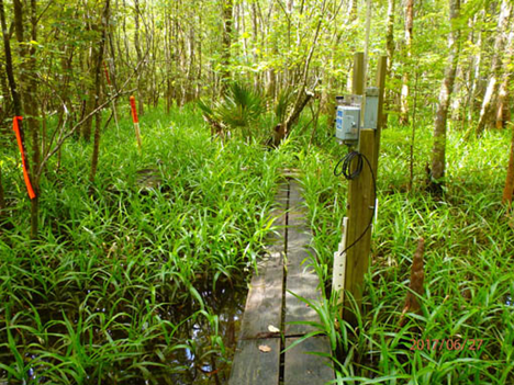
The Coastwide Reference Monitoring System (CRMS), funded by the Coastal Wetlands Planning, Protection, and Restoration Act (CWPPRA), monitors how effective restoration acts are across multiple spatial scales. The system monitors approximately 390 sites with about 13 falling within St. John the Baptist Parish. View the CRMS map viewer here.
These certificates are required to determine compliance with Base Flood Elevation (BFE) requirements when building a new structure or mitigating a structure that has been repetitively flooded or substantially damaged. A licensed surveyor must provide this form. Some completed certificates are on file in the Planning & Zoning Dept. for structures built after 2000. Copies of these certificates can be obtained by emailing StJohnFloodplain@stjohn-la.gov or calling the department at 651-5565.The list of properties that Planning & Zoning has on file can be found here(PDF, 599KB).
For inquiries about the National Flood Insurance Program write:
Federal Emergency Management Agency
Federal Insurance Administration
500 C. Street, S. W.
Washington, DC 20472
Read more about elevation certificates here.
Or visit: https://www.floodsmart.gov/
 >
>